![](/images/other/stat-length.png)
![Trail Walking La Ferrière - Autout de La Ferrière et Marray - Photo](https://media.geolcdn.com/t/1900/400/ext.pjpeg?maxdim=2&url=https%3A%2F%2Fstatic1.geolcdn.com%2Fsiteimages%2Fupload%2Ffiles%2F1553511878bg_sport_marche.png)
Autout de La Ferrière et Marray
tracegps
User
![Length](/images/other/stat-length.png)
Length
16.7 km
![Max alt](https://static1.geolcdn.com/siteimages/upload/files/1508320355ic_sort_altitude_max_24dp.png)
Max alt
186 m
![Uphill gradient](https://static1.geolcdn.com/siteimages/upload/files/1508320355ic_sort_den_pos_24dp.png)
Uphill gradient
219 m
![Km-Effort](/images/other/stat-length.png)
Km-Effort
19.6 km
![Min alt](https://static1.geolcdn.com/siteimages/upload/files/1508320355ic_sort_altitude_min_24dp.png)
Min alt
98 m
![Downhill gradient](https://static1.geolcdn.com/siteimages/upload/files/1508320355ic_sort_den_neg_24dp.png)
Downhill gradient
219 m
![Boucle](https://static1.geolcdn.com/siteimages/upload/files/16400158638029165_repeat_loop_refresh_sync_direction_icon.png)
Boucle
Yes
Creation date :
2014-12-10 00:00:00.0
Updated on :
2014-12-10 00:00:00.0
![Walking](https://static1.geolcdn.com/sitytour/trail-icons/101.png)
3h00
Difficulty : Medium
![Scan this QR Code to open this trail in the SityTrail application](https://capi.geolives.com/qq0zvz2zws4bq2lad0pu/sitytour/trails/102363/qr.png?size=200)
FREE GPS app for hiking
About
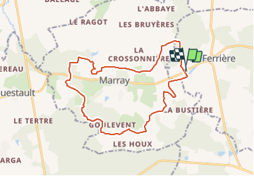
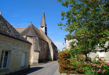
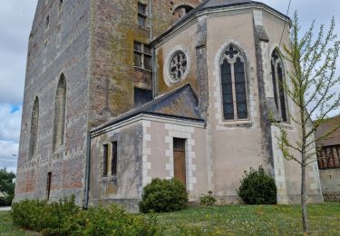
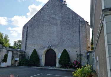
Trail Walking of 16.7 km to be discovered at Centre-Loire Valley, Indre-et-Loire, La Ferrière. This trail is proposed by tracegps.
Description
Boucle autour de La Ferrière et Marray, 17km avec beaucoup de forêt, balisage bleu, balisage temporaire probable, circuit proposé pour une sortie du comité local.
Positioning
Country:
France
Region :
Centre-Loire Valley
Department/Province :
Indre-et-Loire
Municipality :
La Ferrière
Location:
Unknown
Start:(Dec)
Start:(UTM)
329721 ; 5276997 (31T) N.
Comments
Trails nearby
![Trail Walking Saint-Laurent-en-Gâtines - Saint-Laurent-en-Gâtines - variante du PR Chemin de Chenusson - 10.2km 90m 2h25 - 2023 07 30 - Photo](https://media.geolcdn.com/t/375/260/9480277e-5582-454b-ba7d-ba1780556f7f.jpg&format=jpg&maxdim=2)
![Walking Walking](https://static1.geolcdn.com/sitytour/trail-icons/101.png)
Saint-Laurent-en-Gâtines - variante du PR Chemin de Chenusson - 10.2km 90m 2h...
Walking
Easy
Saint-Laurent-en-Gâtines,
Centre-Loire Valley,
Indre-et-Loire,
France
![](/images/other/stat-length.png)
10.3 km | 11.5 km-effort
2h 25min
![](https://static1.geolcdn.com/siteimages/upload/files/16400158638029165_repeat_loop_refresh_sync_direction_icon.png)
Yes
![Trail Walking La Ferrière - la Ferrière - le Moulin à Vent à Saint-Laurent-en-Gâtines - 14.9km 115m 3h20 (30mn) - 2023 07 30 - Photo](https://media.geolcdn.com/t/375/260/d3c77c4c-8983-42fc-ab09-ce988903c800.jpg&format=jpg&maxdim=2)
![Walking Walking](https://static1.geolcdn.com/sitytour/trail-icons/101.png)
la Ferrière - le Moulin à Vent à Saint-Laurent-en-Gâtines - 14.9km 115m 3h20 ...
Walking
Easy
La Ferrière,
Centre-Loire Valley,
Indre-et-Loire,
France
![](/images/other/stat-length.png)
14.9 km | 16.5 km-effort
3h 20min
![](https://static1.geolcdn.com/siteimages/upload/files/16400158638029165_repeat_loop_refresh_sync_direction_icon.png)
Yes
![Trail Walking Saint-Laurent-en-Gâtines - Saint-Laurent-en-Gâtines - Circuit jaune avec variante le Sentier - 18.7km 120m 4h30 - 2022 05 01 - Photo](https://media.geolcdn.com/t/375/260/8fa477e2-239d-46b3-938e-82d894cde1c1.jpg&format=jpg&maxdim=2)
![Walking Walking](https://static1.geolcdn.com/sitytour/trail-icons/101.png)
Saint-Laurent-en-Gâtines - Circuit jaune avec variante le Sentier - 18.7km 12...
Walking
Easy
Saint-Laurent-en-Gâtines,
Centre-Loire Valley,
Indre-et-Loire,
France
![](/images/other/stat-length.png)
18.7 km | 20 km-effort
4h 30min
![](https://static1.geolcdn.com/siteimages/upload/files/16400158638029165_repeat_loop_refresh_sync_direction_icon.png)
Yes
![Trail Walking Marray - Marray - 2 boucles - 19.2km 245m 5h05 (30mn) - 2021 06 09 - Photo](https://media.geolcdn.com/t/375/260/45a2bb2e-f724-44bd-9abd-5e3ed1735943.jpg&format=jpg&maxdim=2)
![Walking Walking](https://static1.geolcdn.com/sitytour/trail-icons/101.png)
Marray - 2 boucles - 19.2km 245m 5h05 (30mn) - 2021 06 09
Walking
Medium
Marray,
Centre-Loire Valley,
Indre-et-Loire,
France
![](/images/other/stat-length.png)
19.2 km | 22 km-effort
5h 5min
![](https://static1.geolcdn.com/siteimages/upload/files/16400158638029165_repeat_loop_refresh_sync_direction_icon.png)
Yes
![Trail Walking Saint-Laurent-en-Gâtines - Saint-Laurent-en-Gatines - Photo](https://media.geolcdn.com/t/375/260/3bcc51bc-dce3-484e-8c68-f9b9dd3f130d.jpg&format=jpg&maxdim=2)
![Walking Walking](https://static1.geolcdn.com/sitytour/trail-icons/101.png)
Saint-Laurent-en-Gatines
Walking
Difficult
Saint-Laurent-en-Gâtines,
Centre-Loire Valley,
Indre-et-Loire,
France
![](/images/other/stat-length.png)
13.1 km | 14.9 km-effort
3h 23min
![](https://static1.geolcdn.com/siteimages/upload/files/16400158638029165_repeat_loop_refresh_sync_direction_icon.png)
Yes
![Trail Walking Marray - Marray - Les versants de la Dême - Photo](https://media.geolcdn.com/t/375/260/a9d7133a-9eea-405b-99f5-2661c5c29f57.jpg&format=jpg&maxdim=2)
![Walking Walking](https://static1.geolcdn.com/sitytour/trail-icons/101.png)
Marray - Les versants de la Dême
Walking
Medium
Marray,
Centre-Loire Valley,
Indre-et-Loire,
France
![](/images/other/stat-length.png)
12.8 km | 15.2 km-effort
3h 27min
![](https://static1.geolcdn.com/siteimages/upload/files/16400158638029165_repeat_loop_refresh_sync_direction_icon.png)
Yes
![Trail Walking La Ferrière - La Ferrière - Photo](https://media.geolcdn.com/t/375/260/2b9da9c8-3be2-44f6-92a4-c42159cd8b74.jpg&format=jpg&maxdim=2)
![Walking Walking](https://static1.geolcdn.com/sitytour/trail-icons/101.png)
La Ferrière
Walking
Easy
La Ferrière,
Centre-Loire Valley,
Indre-et-Loire,
France
![](/images/other/stat-length.png)
10.6 km | 11.9 km-effort
2h 42min
![](https://static1.geolcdn.com/siteimages/upload/files/16400158638029165_repeat_loop_refresh_sync_direction_icon.png)
Yes
![Trail Walking Les Hermites - sentier de l'ermite - Photo](https://media.geolcdn.com/t/375/260/ext.jpg?maxdim=2&url=https%3A%2F%2Fservices.sitytrail.com%2FGeolivesWS%2FDownloadMedia.ashx%3FTrailID%3D315383%26Media%3Dfix__20140622121912.jpg)
![Walking Walking](https://static1.geolcdn.com/sitytour/trail-icons/101.png)
sentier de l'ermite
Walking
Very easy
Les Hermites,
Centre-Loire Valley,
Indre-et-Loire,
France
![](/images/other/stat-length.png)
25 km | 28 km-effort
5h 29min
![](https://static1.geolcdn.com/siteimages/upload/files/16400158638029165_repeat_loop_refresh_sync_direction_icon.png)
Yes
![Trail Walking Saint-Laurent-en-Gâtines - saint laurent en gatine - Photo](https://media.geolcdn.com/t/375/260/ext.jpg?maxdim=2&url=https%3A%2F%2Fservices.sitytrail.com%2FGeolivesWS%2FDownloadMedia.ashx%3FTrailID%3D265906%26Media%3Dfix__20140412112239.jpg)
![Walking Walking](https://static1.geolcdn.com/sitytour/trail-icons/101.png)
saint laurent en gatine
Walking
Easy
Saint-Laurent-en-Gâtines,
Centre-Loire Valley,
Indre-et-Loire,
France
![](/images/other/stat-length.png)
13.9 km | 14.9 km-effort
2h 59min
![](https://static1.geolcdn.com/siteimages/upload/files/16400158638029165_repeat_loop_refresh_sync_direction_icon.png)
Yes